Storms, hail and colder temps hitting Texas. What to know for the weekend
After a stretch of warm January days, Texas is shifting back toward more familiar winter weather.
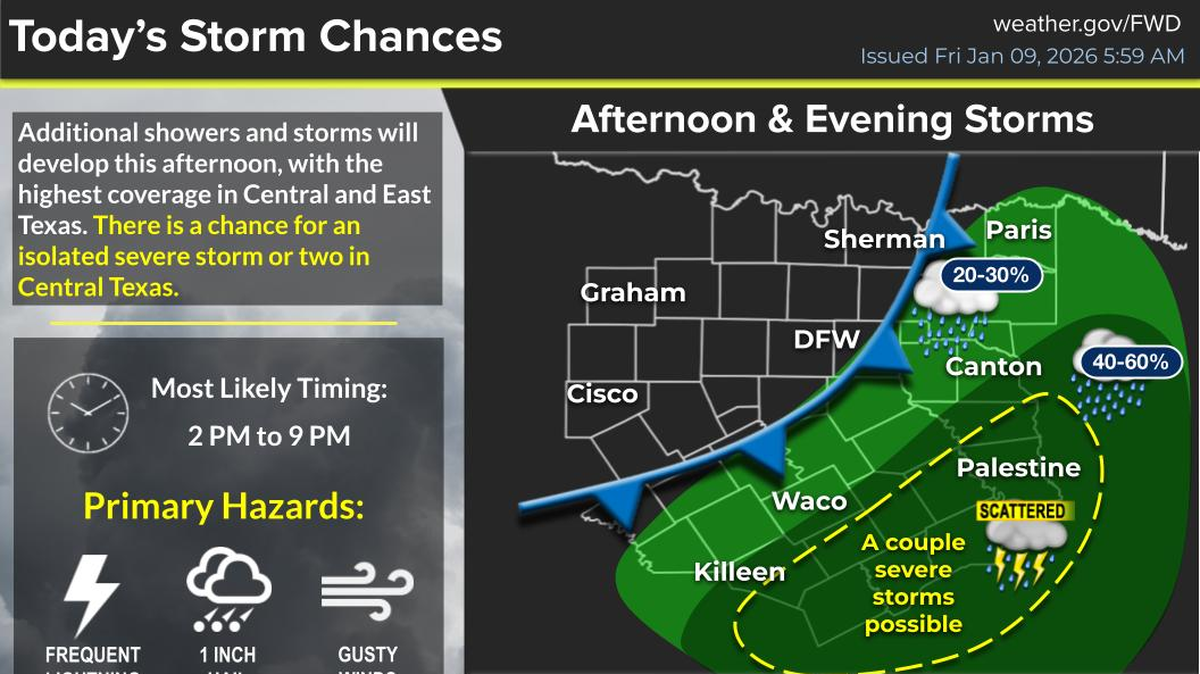
Storm chances are rising in parts of East and Central Texas where a front has basically parked itself and created the ingredients for scattered storms Friday afternoon.
North Texas will stay out of most of that activity, but a stronger cold front is lined up to move through the Dallas Fort Worth area Friday night.
With cooler air, breezy conditions, and quieter weather settling in, here’s what to know about the weekend forecast.
What storms are expected in Texas?
Much of the active weather is positioned southeast of the Metroplex. The National Weather Service says that’s where the storm potential sits for the rest of Friday.
Meteorologist David Bonnette with the National Weather Service in Fort Worth said a stalled cold front has created the setup for this round of storms. He described it as a boundary with enough moisture and instability to spark scattered development.
“Along and ahead of that front, we’ll have some isolated to scattered showers and thunderstorms,” Bonnette said. “Some of those will have potential to produce severe weather with mainly a low hail and a low wind risk.”
He said any kind of tornadoes will remain well off over Southeast Texas into Louisiana.
This activity is expected to stay focused outside of North Texas, but it’s still something to keep an eye on if you have friends or family in the Southeast.
How long will the storms last?
The storms are not expected to linger over the weekend.
“That’s just for Friday afternoon and evening, and then the storm system should move east,” Bonnette said.
Behind the storms comes a stronger cold front for the Metroplex.
Once it moves in, temperatures fall back to normal January levels, setting up a cooler and calmer stretch through early next week.
When will North Texas feel the colder air?
North Texans can expect the full push of colder air to settle in overnight and into Saturday.
“Within the Metroplex we’re going to have a pretty strong cold front move through tonight, and that will lower temperatures back down to near their seasonal normal,” Bonnette said.
“So this weekend, you can expect highs in the 50s and low temperatures in at 30, with pretty quiet weather for the rest of the week.”
If you have outdoor plans, prepare for a real shift from the warmth we’ve seen since the start of January.
Will next week stay cold?
For the most part, yes. Bonnette said Saturday will bring breezy northwest winds before conditions settle further.
“Saturday will be the only day when it’ll be somewhat breezy. Temperatures will warm into the mid 50s, but the winds will be out of the Northwest, between about 15 to 20 miles an hour with occasional gusts to maybe 30 miles an hour,” he said.
After that, the area should see stable, dry winter weather for several days.
Is this cold front unusual for January?
After two weeks of warmer weather the cooler temperatures may feel abrupt, but Bonnette said this pattern lines up with typical winter behavior.
“We just have cold air coming from the north, it’s nothing too abnormal,” he said.
The National Weather Service also notes that seasonal highs for early to mid-January sit in the mid-50s for North Texas, which is right where temperatures will land after Fridays front.
This story was originally published January 9, 2026 at 12:47 PM.